The ambitious €2.9m 3D-PITOTI project involves a multidisciplinary team of over 30 scientists from across Europe and focuses on rock art in the Valcamonica Valley, Italy. This UNESCO World Heritage site in the Lombardy region of northern Italy has the largest group of this ‘rock art’ in Europe. Tens of thousands of images span a period from many centuries BC into medieval times.
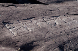
Unlike the famous prehistoric European art found protected from the elements deep in a handful of limestone caves, the simple open-air rock carvings have been left exposed to the elements for over 7000 years. They might be widespread across most European countries but they are now so badly eroded that they can only be seen when the light shines on them from a certain direction. These “Pitoti” (meaning little puppet in the local dialect) are simple but beguiling carvings with extraordinary graphics and appearing in a vast range of forms and depictions. This wealth of Europe’s cultural heritage provides autobiographical stories from our ancient past. What European rock-art gives us is the world of prehistoric Europeans, as they themselves experienced it and understood it.
3D-Pitoti Scanner
The 3D-PITOTI Scanner is capable to record at the sub-millimetre scale a faithful digital reproduction of rock-art. The 3D-Pitoti Scanner does not require ground control points because of its capability of outside-in tracking and scale information. This is accomplished by the combination of tachymeter-based tracking of the scanner, calibrated stereo and SfM. Two Li-Po batteries allow a constant data acquisition for a full day.For the acquisition of the colour information, the 3D-Pitoti Scanner is equipped with a custom made flash providing up to 165000 lx. Each time two pictures are taken, one with flash and one without flash for the further radiometric processing of the data. For geometry measurement extend Structure-from-Motion with constrained bundle adjustment post processing is used to obtain geo-referenced Euclidean reconstructions. Frame differencing of images with and without intense artificial illumination is used to eliminate the influence of ambient illumination and the radiometric surface properties are calculated based on known illumination configuration and radiometric calibration. Calculating the relations between surface normal, camera pose, and incident light leads to the final result of dense 3D point clouds that represent radiometric surface properties.During data acquisition the 3D-Pitoti scanner provides instant user feedback on an external tablet. The especially developed online Structure from Motion algorithm allows an in-field preprocessing of the measurement data, providing the user with different information, such as a sparse point cloud, a mesh and the amount of matched pictures.
D-Pitoti UAV view planning
For the mid-range data acquisition, the 3D-Pitoti consortium was using an octocopter UAV. To obtain a good and complete 3D reconstruction, the 3D-Pitoti consortium developed a system, which surpasses the tradition definition of view planning. The system closes the loop between acquisition and reconstruction and works completely on-site without any prior model.
Through iteratively updating the geometry, planning and autonomous execution, our system closes the acquisition and reconstruction loop and is able to deal with inaccurate scene estimates as well as imperfect plan execution.
One of our key novelties of our approach is that we specifically learned the requirements of the final densification step with respect to the camera constellation and the scene characteristics. During the project, we demonstrated that this novel feature can significantly improve the resulting 3D reconstruction in coverage and accuracy
3D-Pitoti Database Module
An archaeological rock-art database was developed. This 3D-Pitoti Module is capable of storing different data, such as survey data, 3D-Pitoti Scanner data, text and all other information necessary for the study of rock art. The 3D-Pitoti module of aspect 3D comprises all the different algorithms developed within this project.
Automatic detection of the cameras and camera calibration data
Automatic detection of total station data
Creation of OrthoDepthImages for Automatic Segmentation
Manual Segmentation on point clouds
Creation of DSM for further use in GIS
Retexturing of meshes for better texture quality
The principles of the database are single Point of Activities. They link the pure 3D geometry with the regular data such as jpgs, films, txt but as well with the information about the point.
The later include predefined tables, which are unique to every Point of Activity. Currently there are three different Point of Activities: Geology, Data Acquisition and Archaeology.
Find more tutorials on Vimeo and aspect3D.
3D-Pitoti Segmentation, Classification and Peckstyle Analysis
The 3D-Pitoti project has developed different techniques for the (semi-)automated computational analysis of petroglyphs. Processing the high-resolution scans of Valcamonica rock art involved developing new techniques such as (semi-)automated segmentation of the rock surface in pecked and non-pecked regions, the automated classification of Pitoti shapes and the investigation of pecking style similarity.
For the investigation of pecking style similarity, different approaches have been developed, using different input spaces (point cloud space and image space) and different types of sampling (dense and topology-based).
The automated shape classification of Pitoti into types of different typologies we developed allows the automated typing of Pitoti figures and can clearly enhance and make more productive the classification work of a rock-art researcher. In addition, automatic and semi-automatic segmentation tools for the extraction of petroglyph shapes from 3D reconstructions have been developed.
The method clearly outperforms 2D color-based segmentation on photographs and yields a high generalization ability even with a very limited amount of training data. This segmentation method has the potential to bridge the gap that exists between 3D reconstruction of rock surfaces and higher-level shape analysis of petroglyphs. Thus, we expect that the proposed method will facilitate the documentation of rock-art in future.
Find some of the software on GitHub.
3D-Pitoti Scientists’ Lab
The 3D-Pitoti Scientists’ Lab is a prototypical visualization infrastructure for the collaborative exploration and analysis of large and complex 3D scanning data. Its core elements are two multi-user 3D displays, a real-time rendering system for large 3D point clouds, and a suite of collaborative 3D interaction techniques.
The system is based on multi-user 3D projection technology that provides individual stereoscopic image pairs for multiple users. All involved users perceive the shared 3D scene from their own physical viewing position. As a result, the physical interaction space of multiple users and the displayed 3D scene merge to a coherent mixed reality. The two physical screens and additional virtual views complement each other and support frequent transitioning between closely and loosely coupled cooperation.
All viewing devices support multiscale 3D navigation through dedicated controllers or multitouch input. A virtual torch allows users to highlight the geometric structure of Pitoti figures through the effects of light and shadow on the rock surface.
Find some the software on GitHub.
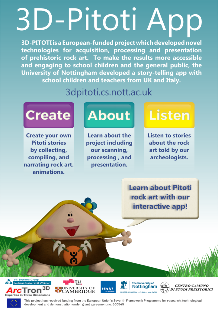
3D-Pitoti Storytelling App
A story-telling app was created with school children and teachers from the UK and Italy to make the results of the project more engaging. The 3D-Pitoti story-telling app provides information about the rock art in the valley of Valcamonica with explanations and interpretations of different archaeologists.
However the highlight of the app is the augmented reality (AR) “Create” part which uses AR markers to enable the user to see animated Pitoti figures and to record their own Pitoti storyline. The resulting story can be explained in a short spoken story and shared with other people. The app will be in use at the tours of Archeocamuni.
Find the App here: http://3dpitoti.cs.nott.ac.uk
Find the markers here: Markerpad Storytelling App
3D-Pitoti Pitoti Prometheus and digital exhibition
A 3D film called „Pitoti Prometheus“ is one of the outputs of the 3D-Pitoti project. This film tells the story of Goethe’s Prometheus using the setting of Valcamonica and the Pitoti figures. The actors are 3D point clouds, recorded at the Interactive Performance Lab at the Bauhaus University at Weimar.
In addition a virtual 3D Pitoti exhibition can be visited. The three dimensional scans have been made with a specially created scanner and processed with the 3D Pitoti Pipeline. In our display the digital ‚puppets‘ start to move, when the visitor gets close enough.
Use this link to visit the exhibition and please leave a comment in the electronic visitor’s book
This project has received funding from the European Union’s Seventh Framework Programme for research, technological development and demonstration under grant agreement no 600545.
In collaboration and by permission of the Ministero dei beni e delle attività cultural e del turismo, Soprintendenza Archeologia della Lombardia.
Copyright © 2015 3D-PITOTI.EU. All Rights Reserved.